


Source de Jérusalem

Renefrt
User
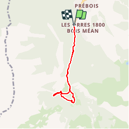

Length
5.4 km

Max alt
1954 m

Uphill gradient
340 m
Km-Effort
10 km

Min alt
1659 m

Downhill gradient
340 m
Boucle
Yes
Creation date :
2019-04-24 11:19:12.429
Updated on :
2019-04-24 11:19:12.429
--
Difficulty : Unknown

FREE GPS app for hiking
 SityTrail
IGN / Geographical institutes
SityTrail Plus
The world is yours!
About
Trail Other activity of 5.4 km to be discovered at Provence-Alpes-Côte d'Azur, Hautes-Alpes, Les Orres. This trail is proposed by Renefrt.


Positioning
Country:
France
Region :
Provence-Alpes-Côte d'Azur
Department/Province :
Hautes-Alpes
Municipality :
Les Orres
Location:
Unknown
Start:(Dec)
Start:(UTM)
305184 ; 4928666 (32T) N.
Comments
La distance indiquée est au bas de la source, juste un visuel.